Skip to content
LEGENDS
OF ROMANIA
RO
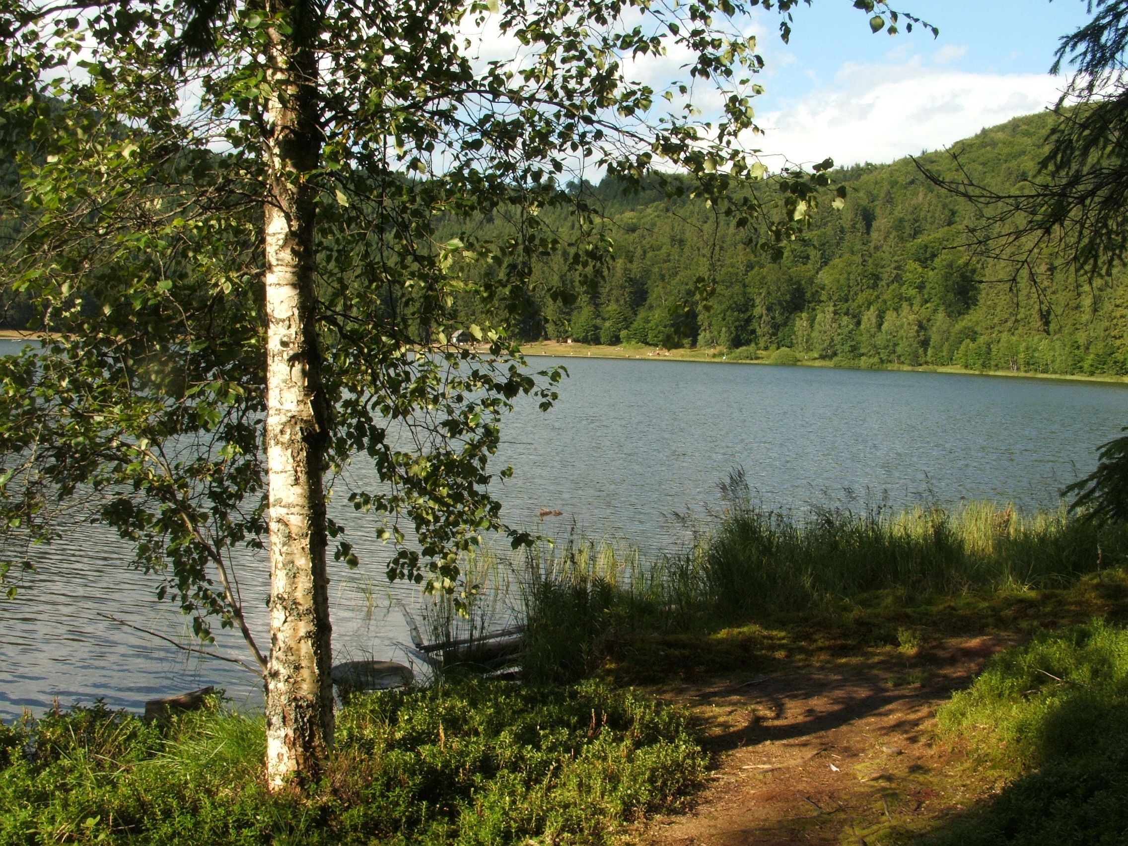
Lake Saint Anne surrounded by the forested slopes of its crater.

Waters

Lake Saint Anne · Ciomad massif, near Băile Tușnad

Lake Saint Anne

Romania’s only volcanic crater lake, hidden in the Ciomad massif, where the water seems quieter than the place around it.

Photo: Várkonyi Tibor · CC BY-SA 4.0 · cropped and optimised for the web

Quick facts and editorial frame

The place at a glance

Real place
Lake Saint Anne[1][3]
Type
Volcanic crater lake[4][5]
Region
Ciomad massif, near Băile Tușnad[1]
Altitude
949–950 M

Elevation of the lake surface stated on the official page.

[1][9]
Visit duration
1–2 Hours for the lake; longer if combined with Mohos Peat Bog
Access
Road access to the visitor area, then a walk down to the lake

Check the official page for opening hours, parking, prices, and rules on the day of your visit.

[1][2]
Season
Open year-round on a seasonal schedule; check official opening hours and last entry[2]
Suitable for
Nature, photography, quiet travel, families with attention to rules

Featured legend

The Lake That Does Not Want to Be Found

A legend about silent water, a bad thought, and the memories some places return to us in altered form.

My grandmother used to say that Lake Saint Anne never stays in the same place twice.

Not because it moves. Water does not walk about on its own, and she knew that too. But she insisted that each person comes down from the crater with a different lake in mind. If you climb with a clear thought, you remember the water. If you climb with a bad thought, the lake keeps it and returns a memory you can no longer trust.

At twelve, I did not believe in her stories. I believed in encyclopaedias.

The encyclopaedia said that Saint Anne is Romania’s only volcanic lake, lying in the crater of the Ciomad massif. It was approximately six hundred and twenty metres long, four hundred and sixty metres across at its widest point, and a little over six metres at its deepest. The figures were precise. Figures did not change their story from one evening to the next.

My grandmother did not argue with figures.

“They measure the water,” she would say. “They do not measure what you take with you when you leave.”

I first went to the lake with my family when I was eight. I remembered the climb through the forest and the air turning suddenly cold before the crater. I remembered the water as round, green, and still. I remembered the birds falling silent at the shore and my father taking a photograph in which I refused to look at the camera.

Years later, I would discover that almost nothing in the photograph matched what I remembered.

My grandmother’s story began with a shepherd named Avram.

He had come from Sâncrăieni with the sheep one spring at the beginning of the eighteenth century, when a few monks lived beside the lake in a small hermitage. Avram had heard that an ancient treasure lay at the bottom of the water. Gold, weapons, and precious stones—things no one had seen, but whose value many could describe exactly.

At the evening meal, Avram asked the monks to help him search.

Ilarion, the oldest among them, asked what he would do if he found nothing.

“I will go back,” Avram replied.

“Not what you will do,” said the monk. “What will your thought do?”

Avram laughed. That night, he went down to the water alone with a rope and a rake tied to its end. He cast the tool into the lake and drew it slowly across the bottom, waiting for the touch of metal.

In the morning, the monks found him on the shore. The rope lay beside him, dry and carefully coiled, as though it had never been used.

Avram insisted that the water had pulled it from his hands.

Later that same day, he said he had never had a rope. After a week, he remembered finding the gold but leaving it there of his own will. After a month, he could no longer say on which side of the lake the hermitage stood. He drew it sometimes to the north, sometimes to the south, and sometimes in the middle of the water itself.

He took the flock down to the village and lived for many years. Whenever someone asked him about Saint Anne, he described a different road, a different shore, and a different night. Every memory seemed true while he told it. None resembled the one before.

One spring, he tried to return. He climbed almost as far as the crater and stopped at a crossroads the other shepherds said they could not see. Three paths began in the same place, and Avram recognised every one of them.

He could not choose.

He returned to the village and never tried again.

“Did the lake punish him?” I asked my grandmother.

“No,” she said. “It gave his thought back. Only the thought had changed while it was in the water.”

At twelve, Avram’s story seemed to me an elaborate explanation for the shame of a man who had found no treasure.

I decided to climb to the lake alone and prove my grandmother wrong.

That was my bad thought. I wanted no gold, and I meant no one harm. I wanted to return with a description so exact that all her stories would seem ridiculous. I took a notebook, a pencil, and the old encyclopaedia. On the first page, before leaving, I wrote: “A lake is the same lake, whoever looks at it.”

It was September. The summer visitors had gone, and the forest smelled of wet leaves and resin. I descended into the crater, counting the bends in the path. At the seventh, I saw the water between the trees.

The lake was there.

Not a false lake. Not an apparition. The same green surface surrounded by forested slopes, more oval than the perfect circle in my memory.

I sat on the shore and began to write. The colour of the water. The shape of the clouds. The roots beside me. The number of steps to the edge of the forest. I recorded everything that seemed impossible to dispute.

After a while, I noticed that the page was still blank.

The pencil was in my hand, but I did not remember writing anything. I turned the page. On the next one, I found a sentence:

“The water was black and the wind was blowing.”

It was my handwriting.

The water before me was green. The air did not move.

I tore out the page, crushed it, and put it in my pocket. Then I wrote again, pressing so hard that the pencil point scratched the paper.

This time, I watched every word until I had finished it.

When I looked up, I no longer knew what I had wanted to prove.

I had not forgotten where I was. I knew the lake’s name, the figures in the encyclopaedia, and the path by which I had come. But the thought that had brought me there was gone. In its place remained a silence without edges, like an empty space inside a sentence.

I became afraid and left.

On the way back, I counted twelve bends, although I was certain there had been seven on the way up.

My grandmother was waiting for me. She did not scold me or ask why I had gone alone. She took the notebook, opened it to the first page, and handed it back.

The sentence I had written before leaving was still there.

Beneath it, in the same pencil, a second line had appeared:

“But it does not remain the same in the mind.”

I did not remember writing it.

My grandmother closed the notebook.

“Now do you know why Avram could not find the road?”

I wanted to tell her that I did. Instead, I asked what the lake had looked like when she was there.

She did not answer.

My grandmother died three years later. Among the things she left me was the photograph my father had taken on our first visit.

In the picture, the lake was not round. It was long and slightly crooked, as I had seen it at twelve. I stood at the water’s edge, turned towards the forest.

I had always remembered the photograph being taken from the opposite side, with me looking at the lake.

On the back, in my grandmother’s small handwriting, was a single line:

“Water does not walk on its own. It needs someone to carry it.”

I have not climbed to Saint Anne since. I can point to the lake on a map. I can say how long, wide, and deep it is. I can explain the way there using information more reliable than my memory.

But whenever I try to draw the path to the water from memory, I arrive at a different number of bends.

Perhaps the lake has always remained in the same place.

Perhaps we are the ones who move it each time we remember it.
Documented folklore

Reported local legends

These stories are traditions or accounts associated with the place, not confirmed historical facts and not the original fiction published by Legends of Romania.

01 · To confirm

Anne and the unwanted marriage

A story circulated by Romanian news and travel pages in recent decades says that a girl named Anne, forced to marry, threw herself into the lake, which then took her name.

The cited source demonstrates modern circulation, not origin. We found no ethnographic attestation, old text, or named local informant; this version does not appear in the consulted 1869 and 1926 sources.

[14]

02 · Traditional

The two brothers and the chariot

A legend recorded in writing in 1869 tells of two tyrannical brothers who ruled rival castles. Seeking to outdo his brother, one harnesses girls to a carriage and strikes Anne, who curses him; the castle sinks and the lake appears in its place.

The versions differ substantially: four or six horses, eight or twelve girls, transformations into swans or none, and different accounts of the chapel built by Anne.

Orbán Balázs presented the story in 1869 as a belief on the people’s lips; Elek Benedek published a literary-folklore version in 1926. Neither is historical evidence for the lake’s formation.

[11][12]

03 · Traditional

The fairies and the chapel bell

In Elek Benedek’s published version, fairies live in a golden palace at the bottom of the lake and emerge to sing at night. The chapel bell disturbs their revels, and their queen sends a dwarf to persuade a shepherd to steal it.

A literary-folklore version published in 1926. Other adaptations add characters and plots; they are not combined here into one supposedly fixed tradition.

[12]

04 · Reported

The bottomless lake linked to the sea

In 1869, Orbán Balázs recorded a belief that Lake Saint Anne was a bottomless ‘sea-eye’, linked to the sea and disturbed whenever the sea was stormy. Orbán immediately noted that the belief was unfounded and that the lake does have a bottom.

A belief recorded and rejected as a real explanation by the same nineteenth-century source; modern measurements confirm that the lake has a bottom.

[11]

The real place

What is true here

Beyond its quiet appearance, the lake preserves evidence of a geologically recent eruption, several ecological transformations, and a long relationship between water, forest, and people.

01

Unexpected fact

Well documented

A scientific record with precise wording

A geomorphological study describes Lake Saint Anne as East-Central Europe’s only primary open-water crater lake. The scope of that record matters: it does not mean that this is Europe’s only volcanic lake.

[4]

02

Science

Source-based estimate

The present crater formed approximately 30,000 years ago

Geological dating places the last major phreatomagmatic eruption at about 29,600 years before present. It shaped today’s Lake Saint Anne crater, which is approximately 1.6 kilometres wide.

[4][5]

03

Science

Source-based estimate

The sediments reveal several different lives of the lake

Analyses of pollen, algae, invertebrates, and sediments reconstruct shifts between shallow water, peat accumulation, bog-like conditions, and the return of a higher-level lake during the Holocene. The chronology is approximate and derives from calibrated models.

[6][7]

04

Science

Source-based estimate

The lake has shrunk, but there is no single definitive ‘current’ depth

Sources report approximately 21.3–21.4 hectares in 1909 and 19.3 hectares in 1999–2000. Published depths include 8.3 metres in 1909 and approximately 6 metres in 2000, but later values were obtained using methods and water levels that are not directly comparable. A 2022 study considers only a reduction of at least one metre defensible.

[1][7][9]

05

Science

Source-based estimate

Water enters at the surface and partly leaves underground

The lake has no surface inflow or outflow streams; it is supplied by precipitation and runoff from the crater slopes. For the conditions studied, an isotope investigation estimated approximately 50% evaporative loss, while tritium in sediment pore water was interpreted as evidence of underground discharge into the Ciomad massif.

[7][8]

06

Nature

Well documented

Compacted paths absorb less water than forest soil

Measurements inside the crater found significantly lower infiltration on dirt trails and compacted grass plots than beneath forest. These surfaces generate runoff more readily and can carry sediment towards the lake, whereas forest stands provide effective protection against erosion.

[9]

07

Unexpected fact

Well documented

‘Close to distilled’ does not mean drinking water

The comparison with distilled water comes from descriptions of very low mineralisation, but it is not a modern certificate of purity or potability. A scientific review warns against tourism superlatives, while the operator records organic material, ammonium, and traces associated with human use in more recent samples.

[7][1]

08

History

Well documented

Two annual pilgrimages were recorded in 1869

In Orbán Balázs’s account published in 1869, the lakeside chapel hosted two pilgrimages each year: on Saint Anne’s Day and on the feast known as Kisasszony napja. He recorded that musicians and officers from the Szekler border regiments also attended these gatherings.

[11]

At a glance

Reference facts

Place identity

Lake type
Volcanic crater lake[4][5]
Context
Set inside a crater of the Ciomad massif[4][5]
Protection
Part of the ROSAC0248 Tinovul Mohoș–Lacul Sf. Ana Natura 2000 Special Area of Conservation[3]

Geographic facts

Altitude
949–950 M[1][9]
Area
19.3 Ha (1999–2000 measurement)[1][7]
Length
Approx. 620 m (dimension reported in the 2011 study)[10]
Maximum width
Approx. 460 m (dimension reported in the 2011 study)[10]
Maximum depth
Approx. 6 m in the 2000 measurement; published values differ by year, water level, and method[7][9]

The lake water

Water source
Precipitation and runoff from the crater slopes; no surface inflow or outflow stream[7][8]
Character
Low mineralisation in historical measurements; comparison with distilled water does not establish present purity or potability[7][1]

Visiting notes

Rules
Local visiting rules should be checked before the trip[2]
Swimming
The management plan approved in 2017 prohibits visitor swimming; check the current regulations[13]

Visiting guide

Practical notes

Accessibility
Road access + walkAccess is by road to the visitor area, followed by a walk towards the crater and lake. Check the official page on the day of your visit for access, parking, opening hours, prices, and local rules.
Time & Season
1–2 Hours for the lake; 3–4 hours if also visiting Mohos Peat Bog · Spring–autumnIdeal time: Early morning or late afternoon, when the place is quieter
01

Getting there

The lake lies in the Băile Tușnad–Bixad area, in the Ciomad massif. Access is by road to the visitor area, followed by a walk toward the lake. Before leaving, check current access rules, parking, and any seasonal restrictions.

02

When to go

For a quieter experience, go early in the morning, late in the afternoon, or outside peak season. Spring, summer, and autumn are best for an easy visit.

03

Is it suitable for children?

Yes, with attention to weather, footwear, and pace. The walk down and back up the crater can be tiring for small children, and reserve rules must be strictly followed.

04

Keep in mind

The lake is part of a protected natural area. Do not treat it as just a photo stop: keep quiet, stay on permitted paths, and check current rules before visiting.

Before you go

Safety is part of the journey.

Respect reserve rules, do not enter the water, and check current local information before visiting.

Practical information checked 3 September 2026

  • On the day of your visit, check weather, closures, opening information, and local rules in the official resources.
  • Stay on marked, permitted routes. Turn back if markings, weather, or terrain become unclear or unsafe.
  • Avoid going alone and tell someone your route and expected return time.
  • Carry an offline map, charged phone, water, changing-weather layers, and a first-aid kit; mobile coverage is not guaranteed.
  • Keep your distance from wildlife, never feed it, and follow local bear alerts and instructions.

Official resources and updates

In an emergency, call 112 or 0SALVAMONT (+40 725 826 668) and provide your location and the group’s condition.

Field detail

Notice this

As you descend toward the lake, notice the moment when the sounds of the forest seem to fade and the crater begins to feel like a closed room.

Location

Where it is

The pin shows the attraction location for orientation. It is not automatically a car park, trailhead, or proof of vehicle access.

Exploration

Nearby traces

Documentation

References

Numbers in the text point to the list below. Titles open the external source used for verification.

  1. [1]Lake Saint Anne — Asociația Pro Szent Anna
  2. [2]Opening hours, parking, overnight area, and contact — Asociația Pro Szent Anna
  3. [3]Hotărârea nr. 685 din 25 mai 2022 privind declararea ariilor speciale de conservare — Portal Legislativ, Ministerul Justiției
  4. [4]Morphometrical and geochronological constraints on the youngest eruptive activity in East-Central Europe at the Ciomadul (Csomád) lava dome complex, East Carpathians — Journal of Volcanology and Geothermal Research
  5. [5]The youngest volcanic eruptions in East-Central Europe—new findings from the Ciomadul lava dome complex, East Carpathians, Romania — Geology Today
  6. [6]Palaeolimnology of the last crater lake in the Eastern Carpathian Mountains: a multiproxy study of Holocene hydrological changes — Hydrobiologia
  7. [7]Holocene palaeohydrology and environmental history in the South Harghita Mountains, Romania — Földtani Közlöny
  8. [8]Isotope characteristics of the water and sediment in volcanic Lake Saint Ana, East-Carpathians, Romania — Carpathian Journal of Earth and Environmental Sciences
  9. [9]Analysis of infiltration rates of soils on the inner slopes of the Lake Sfânta Ana crater — Carpathian Journal of Earth and Environmental Sciences
  10. [10]A sedimentation study of St. Ana Lake (Romania) applying the 210Pb and 137Cs dating methods — Geochronometria
  11. [11]XI. Szent-Anna tava — Magyar Elektronikus Könyvtár, Országos Széchényi Könyvtár
  12. [12]Erdélyi népmondák — Magyar Elektronikus Könyvtár, Országos Széchényi Könyvtár
  13. [13]Scăldatul în Lacul Sfânta Ana a fost interzis, pentru protejarea calităţii apei — Știrile ProTV / AGERPRES
  14. [14]Misterele singurului lac vulcanic din România. Lacul Sfânta Ana, de la legenda sacrificiului fecioarei la mirosul din aer care anunţă ploaia — Adevărul